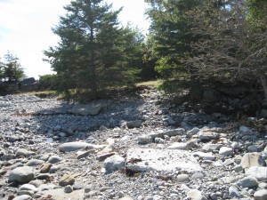
 This launch site was severely damaged by the eastly winds from Huricane Bill, August 2009. It is still accessable, but use caution getting in and out of your kayak around the rocks.
Location: turn off main road, take a left turn onto a gravel road identified by 2 house #’s 4706, and 4708
Shoreline: rocky
Type of access: gravel road
Parking: yes, next to an old boat house
Topographic reference: 20p/11 (Lockeport)
Marine chart # 4241 (Lockeport-Cape Sable)
UTM grid: E0320098 Â N4844759
Latitude: 43° 44.141′ N /Longitude: 65° 14.011′ W
Name of owner: public, this was once a site of an old public wharf.
Â
From this access you can paddle down to and around McLeans Island and explore Upper Island Bay. From there you can paddle to Lower Jordan Bay and exit at the wharf at d’Entremonts Road.
